Grain Brokers Australia News Archives | Page 12 of 17 | Grain Brokers Australia

U.S. Drought Monitor – Released Thu 12 Feb 2015.

Posted by | Grain Brokers Australia News | No Comments

US National Drought Summary – The Plains.

Across the northern and southern Plains states, temperatures were well above normal for the period. During the weekend, record high temperatures were observed in Kansas and South Dakota. In western Kansas, temperatures soared into the high 70s and low 80s, while portions of South Dakota reached the mid-60s. On this week’s map, changes included expansion of Abnormally Dry (D0) into western South Dakota in response to above normal temperatures and precipitation deficits during the past 30 days. In southeastern Kansas, some minor expansion in an area of Moderate Drought (D1) occurred in response to warmer temperatures and deterioration in local stock pond levels.

US Drought Monitor 100215

The U.S. Drought Monitor is produced in partnership between the National Drought Mitigation Center at the University of Nebraska-Lincoln, the United States Department of Agriculture, and the National Oceanic and Atmospheric Administration.

14 of 15 Hottest Years Have Been in 21st Century – WMO.

Posted by | Grain Brokers Australia News | No Comments

Geneva, 2 February 2015 (WMO) The World Meteorological Organization (WMO) has ranked 2014 as the hottest year on record, as part of a continuing trend. After consolidating leading international datasets, WMO noted that the difference in temperature between the warmest years is only a few hundredths of a degree – less than the margin of uncertainty.

Average global air temperatures over land and sea surface in 2014 were 0.57 °C (1.03°F) above the long-term average of 14.00°C (57.2 °F) for the 1961-1990 reference period. By comparison, temperatures were 0.55 °C (1.00°F) above average in 2010 and 0.54°C (0.98°F) above average in 2005,  according to WMO calculations. The estimated margin of uncertainty was 0.10°C (0.18°F).

“The overall warming trend is more important than the ranking of an individual year,” said WMO Secretary-General Michel Jarraud. “Analysis of the datasets indicates that 2014 was nominally the warmest on record, although there is very little difference between the three hottest years,” said Mr Jarraud.

“Fourteen of the fifteen hottest years have all been this century. We expect global warming to continue, given that rising levels of greenhouse gases in the atmosphere and the increasing heat content of the oceans are committing us to a warmer future,” he said.

Around 93% of the excess energy trapped in the atmosphere by greenhouse gases from fossil fuels and other human activities ends up in the oceans. Therefore, the heat content of the oceans is key to understanding the climate system. Global sea-surface temperatures reached record levels in 2014.[1]

It is notable that the high 2014 temperatures occurred in the absence of a fully developed El Niño. El Niño occurs when warmer than average sea-surface temperatures in the eastern tropical Pacific combine, in a self-reinforcing loop, with atmospheric pressure systems. This has an overall warming impact on the climate. High temperatures in 1998 – the hottest year before the 21st century – occurred during a strong El-Niño year.

“In 2014, record-breaking heat combined with torrential rainfall and floods in many countries and drought in some others – consistent with the expectation of a changing climate,” said Mr Jarraud.

Strong weather and climate services are now more necessary than ever before to increase resilience to disasters and help countries and communities adapt to a fast changing and, in many places, less hospitable climate, said Mr Jarraud.

WMO released the global temperature analysis in advance of climate change negotiations to be held in Geneva from 8 to 13 February. These talks will help to pave the way for an agreement on action to be adopted by the Parties to the UN Framework Convention on Climate Change next December in Paris.

The WMO analysis is based, amongst others,  on three complementary datasets maintained by the Hadley Centre of the UK’s Met Office and the Climatic Research Unit, University of East Anglia, United Kingdom (combined); the U.S. National Oceanic and Atmospheric Administration (NOAA) National Climatic Data Centre; and the Goddard Institute of Space Studies (GISS) operated by the National Aeronautics and Space Administration (NASA).

Global average temperatures are also estimated using reanalysis systems, which use the most advanced weather forecasting systems to combine many sources of data to provide a complementary analysis approaches. WMO in particular uses data from the reanalysis produced by the European Centre for Medium-Range Weather Forecasts, which also ranks 2014 as among the four warmest.

The final report on the Status of the Climate in 2014, with full details of regional trends and extreme events, will be available in March 2015.

Weather, Climate and Water

For more information:  Please contact Clare Nullis at +41 22 7308478 or 41 79 709 1397 or cnullis{at)wmo.int. 

The full datasets are available on request


[1] See WMO’s provisional statement on the Status of the Climate in 2014http://www.wmo.int/pages/mediacentre/press_releases/pr_1009_en.html

Information courtesy of the World Meteorological Organisation.

Tropical Pacific Ocean moves from El Niño-like to NEUTRAL.

Posted by | Grain Brokers Australia News | No Comments

Latest ENSO Wrap-Up issued 20 January 2015

The latest ENSO Wrap-Up, ENSO Tracker and Climate Model Summary are now available on the Bureau’s website.

Tropical Pacific Ocean moves from El Niño-like to neutral.

Since late 2014, most ENSO indicators have eased back from borderline El Niño levels. As the natural seasonal cycle of ENSO is now entering the decay phase, and models indicate a low chance of an immediate return to El Niño levels, neutral conditions are considered the most likely scenario through into autumn.

Central tropical Pacific Ocean surface temperatures have fallen by around half a degree from their peak of 1.1°C above average in late November. Likewise, the Southern Oscillation Index has weakened to values more consistent with neutral conditions, while recent cloud patterns show little El Niño signature. As all models surveyed by the Bureau favour a continuation of these neutral conditions in the coming months, the immediate threat of El Niño onset appears passed for the 2014–15 cycle. Hence the ENSO Tracker has been reset to NEUTRAL. The Tracker will remain at NEUTRAL unless observations and model outlooks indicate a heightened risk of either La Niña or El Niño developing later this year.


ENSO Tracker

Our ENSO Tracker provides
up-to-date information on the likelihood
of an El Niño or La Niña developing.

The status is El Niño NEUTRAL.

Information courtesy of the Bureau of Meteorology.

WA (2014) – warmest year on record.

Posted by | Grain Brokers Australia News | No Comments

Tuesday, 6 January 2015 – Annual Climate Summary for Western Australia.

Western Australia in 2014: Warmest year on record

Western Australia recorded its warmest year on record in 2014, in terms of the mean maximum temperature, and saw its ninth-warmest year on record in terms of the mean minimum temperature. The State as a whole recorded above average rainfall in 2014, however below average rainfall was reported for the Southwest Land Division (SWLD).

  • State-wide mean maximum temperature highest on record; highest on record for southwest WA
  • State-wide mean minimum temperature tenth-highest on record; fourth-highest on record for southwest WA
  • WA monthly mean maximum temperatures consistently above average from March to December
  • WA monthly mean minimum temperatures only below average in February, June, and July
  • State-wide rainfall above average
  • Below-average rainfall for the SWLD

Western Australia’s statewide average maximum temperature was 1.17 °C above the historical mean in 2014, the highest since comparable records commenced in 1910 exceeding the record of 1.11 °C set in 2013. The year started with near-average temperatures for WA in January and February, but then saw the eighth-warmest autumn on record, the third-warmest winter, the warmest spring on record, and an above average December. Almost all of the State recorded above average mean annual maximum temperatures in 2014, and sites in the Pilbara, Gascoyne, Central Wheat Belt, Great Southern, and Southeast Coastal registered their warmest or equal-warmest year on record. In the Lower Southwest (southwest of a line from Jurien Bay to Bremer Bay), the mean annual maximum temperature was 1.28 °C above the historical mean, the highest annual mean maximum temperature on record, exceeding the previous highest with an anomaly of 1.27 °C in 2010. The monthly mean maximum temperature for the Lower Southwest was above the average for all months in 2014.

The annual mean minimum temperature averaged across the State was the tenth-highest on record (+0.52 °C anomaly), whilst the Lower Southwest recorded its fourth-warmest year on record in terms of overnight temperatures. Most of WA saw above to very much above average mean minimum temperatures in 2014, with a few sites in the eastern Central Wheat Belt and Goldfields recording their warmest or equal warmest year on record. In contrast, much of the Kimberley, the eastern Northern Interior, and far northeast Southern Interior recorded near average or below average mean minima for 2014.

The statewide average rainfall for 2014 was 406 mm, 19% above the historical average. Rainfall was generally above average across northern, central, and eastern WA in 2014, and Rawlinna Depot in the Eucla registered its wettest year in 44 years of record. However, western parts of the State generally recorded below average rainfall in 2014 and some sites near the west coast, as well as sites near the southern SWLD coast, recorded rainfall totals in their lowest 10% of records, whilst some saw their driest year for at least 20 years. The SWLD as a whole recorded below average rainfall in 2014. In most months during the year, rainfall was near average to above average for the State as a whole, however March, June, and August received below average rainfall through much of WA, and winter rainfall for the State was tenth-lowest on record.

Intense tropical lows moved through WA in January and February 2014 bringing significant rainfall to large parts of the State, whilst two tropical cyclones (Gillian in March and Jack in April) developed in the Indian Ocean well west of WA. No tropical cyclones impacted the WA coastline in the 2014 calendar year, the first year this has occurred since 1951.

Information courtesy of the Bureau of Meteorology.

2014 on course to be, possibly hottest, on record (Globally).

Posted by | Grain Brokers Australia News | No Comments

Lima/Geneva, 3 December 2014 (WMO) – The year 2014 is on track to be one of the hottest, if not the hottest, on record, according to preliminary estimates by the World Meteorological Organization (WMO). This is largely due to record high global sea surface temperatures, which will very likely remain above normal until the end of the year. High sea temperatures, together with other factors, contributed to exceptionally heavy rainfall and floods in many countries and extreme drought in others.

WMO’s provisional statement on the Status of the Global Climate in 2014 indicated that the global average air temperature over land and sea surface for January to October was about 0.57° Centigrade (1.03 Fahrenheit) above the average of 14.00°C (57.2 °F) for the 1961-1990 reference period, and 0.09°C (0.16 °F) above the average for the past ten years (2004-2013).

If November and December maintain the same tendency, then 2014 will likely be the hottest on record, ahead of 2010, 2005 and 1998. This confirms the underlying long-term warming trend. It is important to note that differences in the rankings of the warmest years are a matter of only a few hundredths of a degree, and that different data sets show slightly different rankings.

The high January to October temperatures occurred in the absence of a full El Niño-Southern Oscillation (ENSO). ENSO occurs when warmer than average sea-surface temperatures in the eastern tropical Pacific combine, in a self-reinforcing loop, with atmospheric pressure systems, thus affecting weather patterns globally. During the year, sea surface temperatures increased nearly to El Niño thresholds but this was not coupled with an atmospheric response. However, many weather and climate patterns normally associated with El Niño/Southern Oscillation (ENSO) were observed in many parts of the world.

“The provisional information for 2014 means that fourteen of the fifteen warmest years on record have all occurred in the 21st century,” said WMO Secretary-General Michel Jarraud. “There is no standstill in global warming,” he said.

“What we saw in 2014 is consistent with what we expect from a changing climate. Record-breaking heat combined with torrential rainfall and floods destroyed livelihoods and ruined lives. What is particularly unusual and alarming this year are the high temperatures of vast areas of the ocean surface, including in the northern hemisphere,” he said.

“Record-high greenhouse gas emissions and associated atmospheric concentrations are committing the planet to a much more uncertain and inhospitable future. WMO and its Members will continue to improve forecasts and services to help people cope with more frequent and damaging extreme weather and climate conditions,” said Mr Jarraud.

The provisional statement was published to inform the annual climate change negotiations taking place in Lima, Peru. WMO also updated its acclaimed Weather Reports for the Future series, with scenarios for the weather in 2050 based on the Fifth Assessment report from the Intergovernmental Panel for Climate Change, which is co-sponsored by WMO and the UNEP. Newly added reports are for Peru, France, Viet Nam, Spain, Canada and Norway, painting a compelling picture of what life could be like on a warmer planet.

Christiana Figueres, Executive Secretary UN Framework Convention on Climate Change (UNFCCC), said: “Our climate is changing and every year the risks of extreme weather events and impacts on humanity rise.”

“Fortunately our political climate is changing too with evidence that governments, supported by investors, business and cities are moving towards a meaningful, universal climate agreement in Paris 2015 — an agreement that keeps a global temperature rise below 2 degrees C by putting in place the pathways to a deep de-carbonisation of the world’s economy and climate neutrality or ‘net zero’ in the second half of the century,” said Ms. Figueres.

Information courtesy of the World Meteorological Organisation.

Australia’s warmest spring on record

Posted by | Grain Brokers Australia News | No Comments

Australia’s warmest spring on record

The Bureau of Meteorology has issued a Special Climate Statement.

Key points:

  • Spring 2014 was Australia’s warmest on record
  • Mean temperatures were 1.67 °C above the 1961–1990 average, the largest such departure from the long-term average since national records began in 1910
  • Numerous records were approached or set. For example:
    • Australia’s warmest October day on record, 36.39 °C national mean maximum temperature on 25 October
    • Australia’s warmest maximum temperature anomaly on record for any season
      (+2.33 °C), surpassing +2.17 °C set in autumn 2005
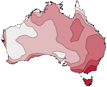
 Spring Record 031214

Australian mean temperature deciles for spring 2014 (1 September to 30 November).
Warmest on record areas are shown in dark orange.

Info courtesy of the Bureau of Meteorology. Issued 3rd Dec 2014.

November USDA Report overnight

Posted by | Grain Brokers Australia News | No Comments

Last night the USDA delivered the monthly WASDE report which was pretty much in line with market expectations, except for a drop in the US corn yield.

Summary of Key Points are –

  • Global wheat production was down 1.3 Mmt due to revisions to production out of Australia, Egypt & Kazakhstan to 719.86 Mmt.
  • Global wheat consumption was down by 1.4 Mmt with global ending stocks raised 0.3 Mmt to 192.9 Mmt.
  • US Corn yields dropped to 173.4 bu/ac and Chinese corn production revised down, lowering global production to 990.32 Mmt.
  • World barley production was raised 0.6 Mmt with barley feed use raised in China too.
  • Global oilseed production projected to be a record 528.9 Mmt with global soybean production also at a record 312.1 Mmt reflecting a strong increase in US production.

Nov USDA 111114

Information courtesy of USDA.

BoM Climate Outlook

Posted by | Grain Brokers Australia News | No Comments

Climate Outlooks issued 25 September 2014
Monthly and seasonal Climate Outlooks for October to December 2014 are now available on the Bureau’s website.

Overview
  • Drier than normal October to December is more likely for large parts of eastern Australia and parts of northwestern Western Australia.
  • Warmer than normal days expected over most of Australia, mostly likely in Tasmania.
  • Climate influences include warmer than normal temperatures in the tropical Pacific Ocean and a neutral Indian Ocean Dipole.
Rainfall

Rainfall Outlook 031014


 Temperature

Temperature Outlook 031014


Climate and water video

Climate & Water Outlook 031014


Chance of exceeding median rainfall for October to December Chance of exceeding median maximum temperature for October to December Brief summary of the rainfall, temperature and streamflow outlooks

Information courtesy of the Bureau of Metereology.

Book Your Free Farm Visit or call us on 1300 946 544 for more information. Free Farm Visit