| El Niño in the tropical PacificThe tropical Pacific is in the early stages of El Niño. Based upon model outlooks and current observations, the Bureau’s ENSO Tracker has been raised to El Niño status.
El Niño–Southern Oscillation (ENSO) indicators have shown a steady trend towards El Niño levels since the start of the year. Sea surface temperatures in the tropical Pacific Ocean have exceeded El Niño thresholds for the past month, supported by warmer-than-average waters below the surface. Trade winds have remained consistently weaker than average since the start of the year, cloudiness at the Date Line has increased and the Southern Oscillation Index (SOI) has remained negative for several months. These indicators suggest the tropical Pacific Ocean and atmosphere have started to couple and reinforce each other, indicating El Niño is likely to persist in the coming months.
International climate models surveyed by the Bureau indicate that tropical Pacific Ocean temperatures are likely to remain above El Niño thresholds through the coming southern winter and at least into spring.
El Niño is often associated with below-average winter and spring rainfall over eastern Australia, and above-average daytime temperatures over the southern half of the country. However, the current May to July outlook suggests much of Australia is likely to be wetter than average. This is because a warmer-than-average Indian Ocean is dominating this outlook. El Niño is expected to become the dominant influence on Australian climate during the second half of the year. |
|
ENSO TrackerOur ENSO Tracker provides
up-to-date information on the likelihood
of an El Niño or La Niña developing.
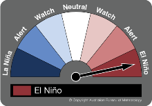
The status is EL NIÑO. |
|
Information courtesy of the Australian Bureau of Meteorology.
Update released – 12 May 2015.