Latest ENSO Wrap-Up issued 14 April 2015
The latest ENSO Wrap-Up, ENSO Tracker and Climate Model Summary are now available on the Bureau’s website.
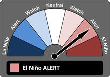
| Tropical Pacific Ocean primed for El Niño in 2015The chances of El Niño occurring in 2015 have increased. Ocean temperatures in the tropical Pacific continue to be warmer than average, trade winds remain weaker than normal, and all models surveyed suggest further ocean warming will occur. As a result, the ENSO Tracker has been raised to El Niño ALERT, indicating at least a 70% chance of El Niño occurring this year.
Tropical Pacific Ocean sea surface temperatures are now just shy of El Niño levels. Large areas of warmer than average water below the surface are likely to keep these waters warm for some time. This increases the odds of atmospheric factors coming into play, and hence further warming of the tropical Pacific Ocean.
All international climate models monitored by the Bureau indicate that El Niño thresholds will be reached or exceeded by June. However, the accuracy of model outlooks during the El Niño–Southern Oscillation (ENSO) transition period is lower than for outlooks made at other times of the year.
El Niño is often associated with below-average winter and spring rainfall over eastern Australia and above-average daytime temperatures over the southern half of Australia. However, April to June is likely to be wetter than average across much of Australia due to very warm conditions in the Indian Ocean. See the latest climate outlook. |
|
ENSO TrackerOur ENSO Tracker provides
up-to-date information on the likelihood
of an El Niño or La Niña developing.
The status is El Niño ALERT.

|
|
Information courtesy of the Bureau of Meteorology.